


Perché questo è difficile
Terrain affects trackers through geometry, and the mechanisms are specific.
- Row straightness is a mechanical requirement, because a torque tube has limited ability to absorb vertical and angular misalignment between foundations
- Slope across a row translates directly into foundation length variation, changing the foundation cost per megawatt and the design of the pile heads
- North-south slope tolerance is generally more generous than east-west, because the tracker rotates about a north-south axis
- Backtracking configuration changes both the shading model and the land requirement, and the optimum differs between flat and sloping ground
- Undulating ground creates local high and low points that determine the deepest foundation on a row, and the whole row is designed for the worst case
- Steep terrain reduces installable density and increases civil works, both of which erode the tracker economic advantage
Requisiti di ingegneria
These are the site data and design decisions that determine terrain feasibility.
- Topographic survey at a resolution that captures the undulation that matters for row alignment, not a coarse site-wide surface
- Permissible slope limits for the tracker in both directions, stated by the manufacturer rather than inferred
- Foundation length range required across the site, with the deepest and shortest cases identified per row
- Backtracking algorithm and its configuration, including whether terrain-following or fixed backtracking is used
- Civil works scope: cut and fill volumes, grading tolerance and any terrace provision required to make rows workable
- Installable density calculation that reflects the terrain-adjusted layout rather than the flat-ground layout
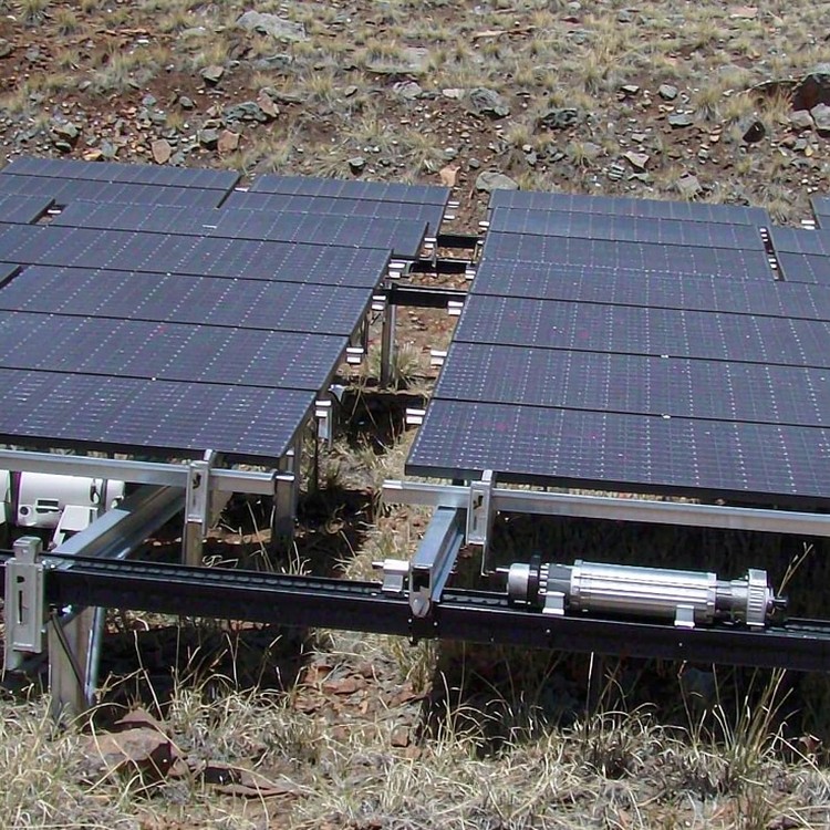
Selection guidance: run the layout on the actual surveyed surface before committing to tracking. A tracker layout developed on a flat plane and applied to a sloping site produces both a cost surprise and a yield shortfall.
Come lo risolviamo
- Layout development on the surveyed surface, so row positions reflect actual ground rather than an idealised plane
- Foundation length variation reported per row, with the deepest case identified so each row is designed against its real governing condition
- Backtracking configured for the site terrain, since the algorithm that suits flat ground is not automatically the right one on a slope
- Slope-aware row direction selection, exploiting the more generous north-south tolerance where the site allows
- Civil works scoped against a defined grading tolerance, so earthworks cost is visible in the comparison rather than discovered during construction
- Installable density calculated from the terrain-adjusted layout, keeping the yield model honest about how much capacity the site actually accepts
Oltre la struttura
- Hybrid deployment where terrain exceeds the tracker practical limits, capturing the gain on the workable portion of the site
- Early terrain feasibility screening, so a site is screened out before significant design effort is spent on a layout it cannot support
Parametri di riferimento
I parametri di riferimento riportati di seguito sono progetti di settore di tipo e dimensioni comparabili, documentati pubblicamente e citati a scopo illustrativo delle migliori pratiche ingegneristiche. Non rappresentano il nostro storico di realizzazione.
- A 200 MW project in Chile on undulating ground where foundation length variation across rows was mapped before design, avoiding over-budget foundation quantities.
- A 150 MW site in Spain where east-west slope forced a terrace solution, and the civil works cost was compared against a fixed-tilt alternative before award.
- A 120 MW project in India where terrain-following backtracking improved production on a north-south slope compared with a fixed backtracking configuration.
Standard e conformità
- Combinazioni di carico del vento ASCE 7 / EN 1991 e sismico EN 1998 / IBC, ove applicabili.
- Livelli di prova di carico meccanico del modulo IEC 61215 adattati alla pressione di progetto del vostro impianto
- Norme EN 1090-1/-2 o classi di esecuzione AISC per componenti in acciaio strutturale
- Zincatura ISO 1461 con massa di zinco a gradini in base alla categoria di corrosività da C2 a C5
- Gestione della qualità ISO 9001:2015 e qualificazione documentata dei fornitori.
- Supporto per la valutazione di bancabilità dei progetti finanziati da parte di DNV o ente equivalente.
Garanzia di qualità
Ogni lotto viene spedito con certificati di produzione, registri dello spessore del rivestimento e documentazione relativa ai bulloni; le saldature sono conformi alle classi di esecuzione EN 1090 o AISC. La garanzia sulla struttura è di 10 anni, a fronte di una vita utile prevista di 25-30 anni, e i pacchetti di ricambi sono documentati in modo che le riparazioni al dodicesimo anno non dipendano dalla memoria del primo anno.
Documentazione che riceverai
La documentazione è pensata per le verifiche, non per essere meramente estetica: note di calcolo strutturale che indicano i casi di carico e gli standard utilizzati; base di progettazione delle fondazioni mappata sulla relazione geotecnica; certificati dei materiali per acciaio e elementi di fissaggio; certificati di zincatura con spessore del rivestimento misurato per lotto; disegni di assemblaggio con tabelle di coppia; e documentazione di imballaggio corrispondente ai manifesti dei container. Per i progetti finanziati aggiungiamo dichiarazioni di conformità nel formato richiesto dall'istituto di credito; per le gare d'appalto pubbliche rispondiamo ai capitolati di documentazione riga per riga.
Pianificazione della durata di servizio e della manutenzione
Plan maintenance around measurable triggers, not calendar guesses: annual visual inspection of fastener torque samples, coating condition at cut edges and ground-contact zones; a detailed inspection after the first extreme weather year; and re-torque verification after the first thermal cycle on long runs. We supply the inspection checklist and acceptance criteria with the installation manual.
Considerazioni di costo e commerciali
- Foundation length variation is the most direct terrain cost, since the deepest foundation on a row governs that row design, so local ground features raise cost disproportionately
- Civil works to achieve grading tolerance can be substantial and must be compared against the yield the tracker will produce on the adjusted layout
- Installable density loss on steep or irregular ground reduces the capacity a given land area supports, which changes the economics rather than just the layout
- Survey cost at the resolution required is modest and prevents the largest category of layout error
- Beyond a certain slope the tracker cannot be adapted economically, and the decision becomes fixed-tilt on the difficult portion rather than more earthworks
Domande frequenti
How steep a slope can a tracker handle?
What is backtracking and why does terrain change it?
When does terrain rule out tracking?
How accurate a survey is needed?
Does terrain affect the yield model?
Guide correlate e pagine applicative
Proseguite con le pagine più pertinenti alla tipologia del vostro progetto.
- Tracker vs Fixed-Tilt Economics – la panoramica del gruppo per questa fascia di scala
- Analisi economica dei tracker ad asse singolo per i progetti di pubblica utilità.
- Piste a inclinazione fissa vs. Piste a inseguimento: confronto tra rendimento e costi
- Applicazioni dei sistemi di tracciamento: terreni complessi e aree ondulate
- Applicazioni del sistema di tracciamento
- Progetti solari su pendii e colline ondulate
Cosa dobbiamo preventivare
- Topographic survey data for the developable area
- Tracker model and its published slope and row-alignment tolerances
- Intended backtracking configuration, or a request for a recommendation
- Earthworks assumptions or constraints, including any restrictions on grading
Rivolgiti a un ingegnere strutturale.
Send the topographic survey and the tracker model you are considering, and we will return a terrain feasibility assessment with the zone map, foundation length range and civil works implications.
 English
 Español
 Deutsch
 Português
 Français
 Italiano