



Por qué esto es difícil
Terrain affects trackers through geometry, and the mechanisms are specific.
- Row straightness is a mechanical requirement, because a torque tube has limited ability to absorb vertical and angular misalignment between foundations
- Slope across a row translates directly into foundation length variation, changing the foundation cost per megawatt and the design of the pile heads
- North-south slope tolerance is generally more generous than east-west, because the tracker rotates about a north-south axis
- Backtracking configuration changes both the shading model and the land requirement, and the optimum differs between flat and sloping ground
- Undulating ground creates local high and low points that determine the deepest foundation on a row, and the whole row is designed for the worst case
- Steep terrain reduces installable density and increases civil works, both of which erode the tracker economic advantage
Requisitos de ingeniería
These are the site data and design decisions that determine terrain feasibility.
- Topographic survey at a resolution that captures the undulation that matters for row alignment, not a coarse site-wide surface
- Permissible slope limits for the tracker in both directions, stated by the manufacturer rather than inferred
- Foundation length range required across the site, with the deepest and shortest cases identified per row
- Backtracking algorithm and its configuration, including whether terrain-following or fixed backtracking is used
- Civil works scope: cut and fill volumes, grading tolerance and any terrace provision required to make rows workable
- Installable density calculation that reflects the terrain-adjusted layout rather than the flat-ground layout
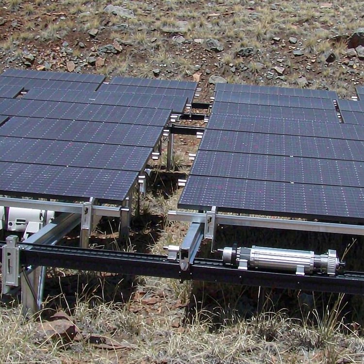
Selection guidance: run the layout on the actual surveyed surface before committing to tracking. A tracker layout developed on a flat plane and applied to a sloping site produces both a cost surprise and a yield shortfall.
Cómo lo resolvemos
- Layout development on the surveyed surface, so row positions reflect actual ground rather than an idealised plane
- Foundation length variation reported per row, with the deepest case identified so each row is designed against its real governing condition
- Backtracking configured for the site terrain, since the algorithm that suits flat ground is not automatically the right one on a slope
- Slope-aware row direction selection, exploiting the more generous north-south tolerance where the site allows
- Civil works scoped against a defined grading tolerance, so earthworks cost is visible in the comparison rather than discovered during construction
- Installable density calculated from the terrain-adjusted layout, keeping the yield model honest about how much capacity the site actually accepts
Más allá de la estructura
- Hybrid deployment where terrain exceeds the tracker practical limits, capturing the gain on the workable portion of the site
- Early terrain feasibility screening, so a site is screened out before significant design effort is spent on a layout it cannot support
Puntos de referencia
Los ejemplos que se muestran a continuación son proyectos de referencia del sector, documentados públicamente y de tipo y escala similares, que se citan para ilustrar la práctica de la ingeniería. No constituyen nuestro historial de proyectos.
- A 200 MW project in Chile on undulating ground where foundation length variation across rows was mapped before design, avoiding over-budget foundation quantities.
- A 150 MW site in Spain where east-west slope forced a terrace solution, and the civil works cost was compared against a fixed-tilt alternative before award.
- A 120 MW project in India where terrain-following backtracking improved production on a north-south slope compared with a fixed backtracking configuration.
Normas y cumplimiento
- Combinaciones de cargas de viento ASCE 7 / EN 1991 y sísmicas EN 1998 / IBC, cuando corresponda.
- Niveles de prueba de carga mecánica del módulo IEC 61215 adaptados a la presión de diseño de su matriz.
- Clases de ejecución EN 1090-1/-2 o AISC para componentes de acero estructural
- Galvanizado ISO 1461 con masa de zinc escalonada según la categoría de corrosividad C2 a C5.
- Gestión de calidad ISO 9001:2015 y cualificación documentada de proveedores.
- Respaldo de DNV o equivalente en la revisión de viabilidad financiera para proyectos financiados.
Seguro de calidad
Cada lote se envía con certificados de fábrica, registros de espesor de recubrimiento y registros de pernos; las soldaduras cumplen con las normas EN 1090 o las clases de ejecución AISC. La garantía de la estructura es de 10 años, frente a una vida útil de diseño de 25 a 30 años, y los paquetes de repuestos están documentados para que las reparaciones del año 12 no dependan de la información del año 1.
Documentación que usted recibe
La documentación está diseñada para auditorías, no para fines decorativos: notas de cálculo estructural que especifican los casos de carga y las normas utilizadas; base de diseño de la cimentación vinculada a su informe geotécnico; certificados de materiales para acero y fijaciones; certificados de galvanizado con espesor de recubrimiento medido por lote; planos de montaje con tablas de par de apriete; y documentación de embalaje que coincide con los manifiestos de los contenedores. Para proyectos financiados, añadimos declaraciones de cumplimiento en formato de entidad financiera; para licitaciones públicas, respondemos a los cronogramas de documentación línea por línea.
Planificación de la vida útil y el mantenimiento
Plan maintenance around measurable triggers, not calendar guesses: annual visual inspection of fastener torque samples, coating condition at cut edges and ground-contact zones; a detailed inspection after the first extreme weather year; and re-torque verification after the first thermal cycle on long runs. We supply the inspection checklist and acceptance criteria with the installation manual.
Costos y consideraciones comerciales
- Foundation length variation is the most direct terrain cost, since the deepest foundation on a row governs that row design, so local ground features raise cost disproportionately
- Civil works to achieve grading tolerance can be substantial and must be compared against the yield the tracker will produce on the adjusted layout
- Installable density loss on steep or irregular ground reduces the capacity a given land area supports, which changes the economics rather than just the layout
- Survey cost at the resolution required is modest and prevents the largest category of layout error
- Beyond a certain slope the tracker cannot be adapted economically, and the decision becomes fixed-tilt on the difficult portion rather than more earthworks
Preguntas frecuentes
How steep a slope can a tracker handle?
What is backtracking and why does terrain change it?
When does terrain rule out tracking?
How accurate a survey is needed?
Does terrain affect the yield model?
Guías y páginas de aplicación relacionadas
Continúa con las páginas más cercanas al tipo de tu proyecto.
- Economía de los vehículos con sistema de seguimiento frente a los vehículos de inclinación fija – la descripción general del grupo para esta banda de escala
- Análisis económico de los sistemas de seguimiento de un solo eje para proyectos de servicios públicos
- Sistema de inclinación fija frente a sistema de seguimiento: comparación de rendimiento y coste
- Aplicaciones de seguimiento: Terrenos complejos y sitios ondulados
- Aplicaciones de sistemas de seguimiento
- Proyectos solares en laderas y pendientes onduladas
Lo que necesitamos citar
- Topographic survey data for the developable area
- Tracker model and its published slope and row-alignment tolerances
- Intended backtracking configuration, or a request for a recommendation
- Earthworks assumptions or constraints, including any restrictions on grading
Hable con un ingeniero estructural.
Send the topographic survey and the tracker model you are considering, and we will return a terrain feasibility assessment with the zone map, foundation length range and civil works implications.
 English
 Español
 Deutsch
 Português
 Français
 Italiano